EYEVIONICS Explained
What You’ll Need
YOU NEED:
The app itself is FREE: Get 2D PFD & MFD, Autopilot, Radio, Nav Data and many more features.
Simply connect the EYEVIONICS app for iOS/Android to Microsoft Flight Simulator.
OPTIONALLY, YOU CAN ADD:
See through the clouds with 3D Terrain for your PFD and MFD. Includes Topographic imagery. Use 3D Terrain and Topo Imagery on 2 devices at a time.
Available as a 1 month or 6 month subscription.
MICROSOFT FLIGHT SIMULATOR
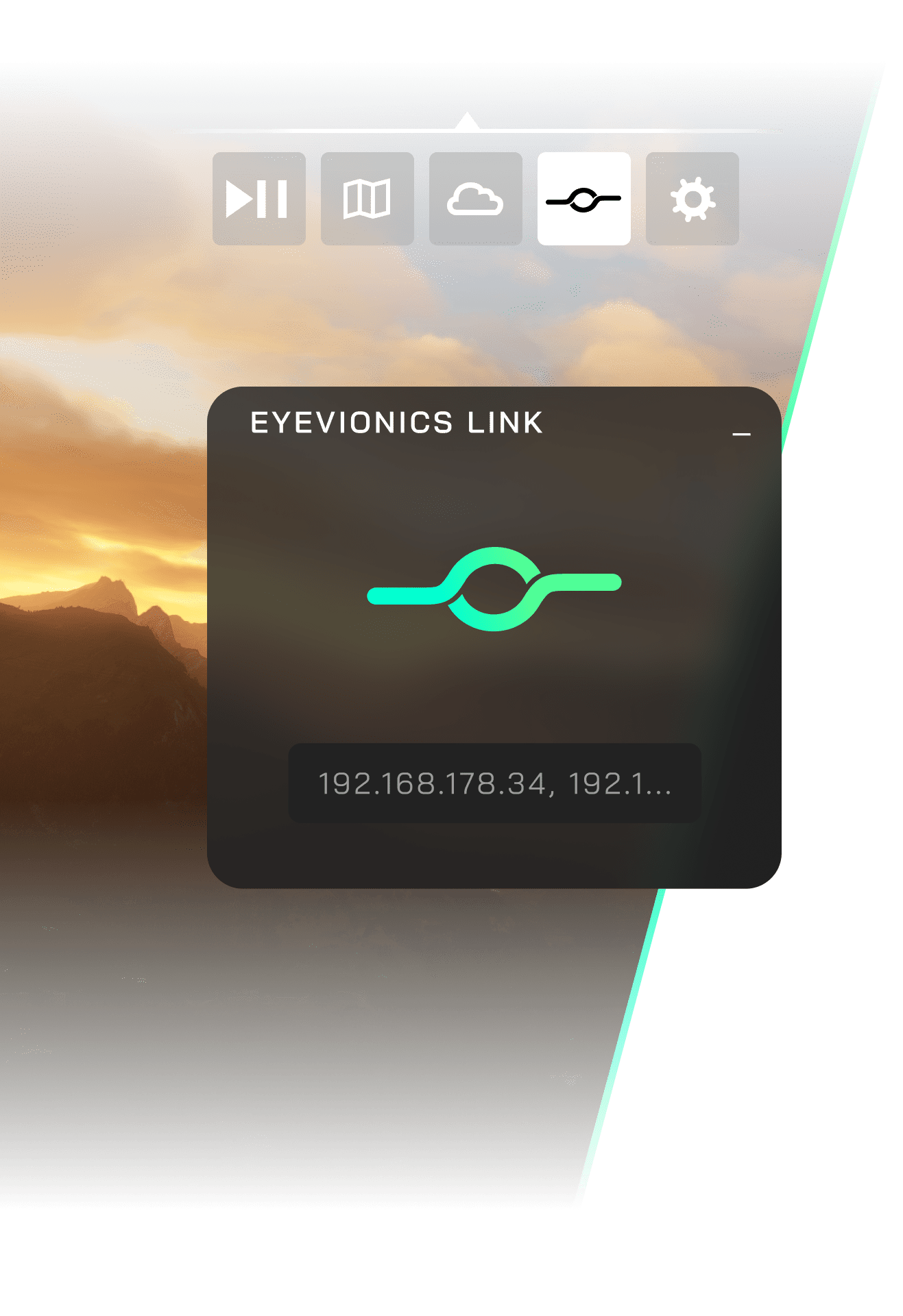
EYEVIONICS LINK
You’ll need the EYEVIONICS Link toolbar add-on to connect Microsoft Flight Simulator to the EYEVIONICS app.
Then, anytime during your flight, simply start the EYEVIONICS app on your tablet, click on the EYEVIONICS toolbar icon in MSFS and you’re ready to go.
FREE AS A BIRD
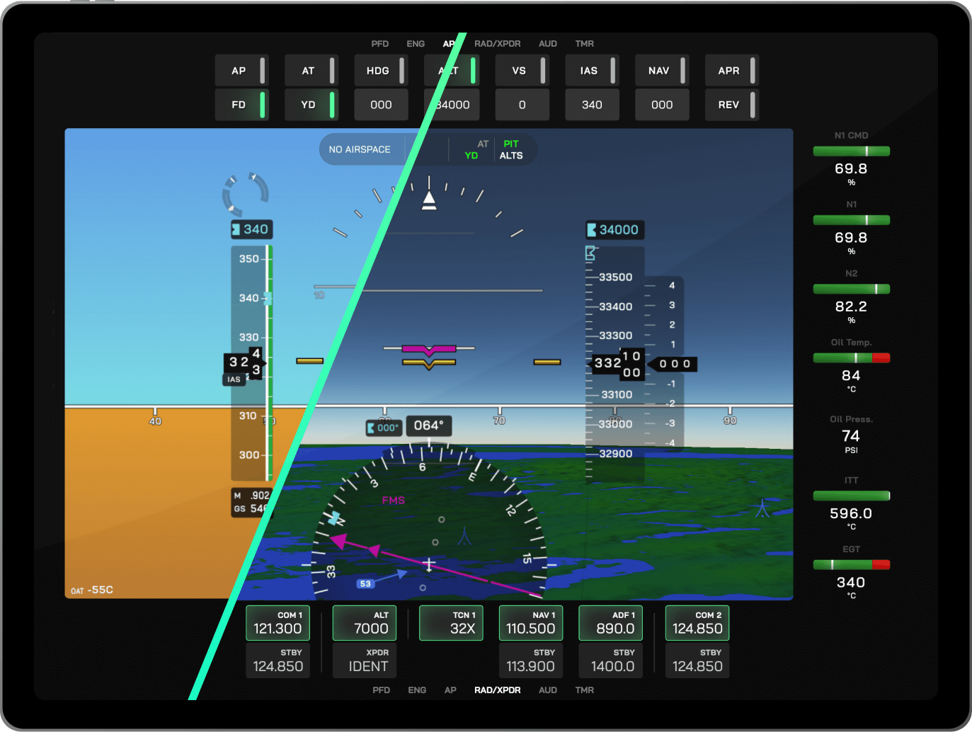
EYEVIONICS APP
The EYEVIONICS app for compatible iOS and Android tablets comes with built-in 2D PFD, 2D MFD, aeronautical navigation data. It features a host of panels for your most important aircraft systems, including Autopilot, Radios, Transponder, Engine Information System and more. The EYEVIONICS app is free.
And if you want advanced features like Topographic Imagery and 3D Terrain for your PFD and MFD or a flight plan panel, the EYEVIONICS Aviator subscription has you covered.
See through the clouds
Aviators Only.

“A superior pilot uses his superior judgment to avoid situations which require the use of his superior skill.” – Frank Borman
Every experienced pilot knows that good aeronautical decision making always relies on one key thing: Situational Awareness. The more of it you have, the safer your decision will be.
With the Flight Plan panel, Topo Imagery, Terrain Alert and 3D Terrain based on EYEVIONICS’ tailor made terrain data, EYEVIONICS AVIATOR supports your situational awareness at all times. If you’re flying a piston prop, a glider, fast jet, a helicopter or anything else, EYEVIONICS AVIATOR let’s you see through the clouds when it figuratively, or literally, comes down to the wire.
Your Decision
For the Aviator in you.
|
ECONOMY Free |
AVIATOR Subscription |
|
|---|---|---|
| PFD & MFD | 2D, no imagery |
3D Terrain Topo Imagery Satellite Imagery 3D Terrain & Imagery on max 2 devices at the same time |
| Terrain Alert | no |
yes in PFD & MFD |
| Customer Support | Forum Support |
Premium Support via email |
| UI & Devices | ||
|
Classic Instruments Basic implementation of the “sixpack”: ASI, AI, Altimeter, TC, HI, VSI. |
yes | |
|
UI Layout Customization Customize your EYEVIONICS app layout to the needs of your personal cockpit. |
yes | |
|
Multi-Device Support Connect your flight sim to multiple devices running EYEVIONICS at the same time. |
Unlimited |
Unlimited, but 3D Terrain & Topo Imagery max 2 devices |
| Panels | ||
|
Flight Plan Panel (Beta) A flight plan panel allowing display and editing of your flight plans for some aircraft types (editing of flight plans for MSFS Garmin aircraft not yet supported). |
no | yes |
| Autopilot Panel | yes | |
|
Smart Engine Information Panel Turbine, Piston, Electric. Automatically displays key engine parameters, including a total fuel indicator. |
yes | |
| Radio Panel | yes | |
| Audio Panel | yes | |
|
Nearest Panel Quickly find the nearest aerodromes, navigation aids, etc. |
yes | |
|
Aeronautical Database Panel Search for aerodromes, heliports, navaids, waypoints and get the information you need, on the fly. |
yes | |
| Time Saving Features | ||
|
Radio Quick Tune Quickly tune comms, nav radios and ADF to frequencies of airports and navaids from within the Aeronautical Database Panel. |
yes | |
|
Aerodrome Weather Tab Check the latest METARs made available by MSFS, for any aerodrome worldwide. Shows the raw METAR as well as a graphical representation. |
yes | |
|
Quick QNH Update Quickly apply the QNH to your altimeter from the Weather Tab in the Aeronautical Database Panel. |
yes | |
| Primary Flight Display & Multifunction Display | ||
|
PFD Inset Map Map displayed in the PFD compass rose. |
no | yes |
|
MFD Top-Down Camera Modes |
North Up Centered Track Up Centered Track Up Forward |
|
|
MFD 3D Follow Camera Birds eye view from behind your aircraft. |
no | yes |
|
MFD 3D Flight Path Prediction No more overshooting base to final turns: See where you’ll fly in the future with an easy to comprehend line in 3D space. |
no | yes |
| Situational Awareness | ||
|
Airspaces in MFD Airspace boundaries visible in the Multifunction Display. |
2D | 2D, 3D |
| Airspace Indication in PFD Altimeter | no | yes |
|
Current Airspace Indicator Shows the airspace you are currently in at the top of your PFD. |
yes | |
|
Traffic Indications See where other aircraft are at any given time. Depending on MSFS versions, traffic may unfortunately not always be available. |
2D in MFD only |
3D, both in PFD & MFD |
| Data, Coverage | ||
|
Aeronautical Database For flight simulation use only. |
yes | |
|
Data Coverage Coverage of 3D Terrain, Topo Imagery and Aeronautical Data. |
ca 70°N to 70°S | |
| 3D Globe Model |
WGS84 (ICAO Standard) |
|